

The 2015 Alan M. and Nathalie Voorhees Lecture on the History of Cartography will be held at the Library of Virginia on Saturday, 18 April. This year’s lecture features two guest speakers: Dr. Susan Schulten will speak on “The Sectional Crisis and The Reinvention of Cartography,” and Cassandra Britt Farrell will give a talk entitled “Field of Battle: A Changing Landscape.” This event includes a special one-day exhibition of maps relating to the talks from 11 a.m. to 4 p.m. Today on Out of the Box we present a sneak preview of two of the maps from the Library’s collection that will be on display.
The map by Edwin Hergesheimer (right) represents the distribution of slaves in the commonwealth based on information gleaned from the U.S. Population Census of 1860. Gray tints indicate the percentage of slaves in each county, highlighting a significant regional difference between the northwestern counties, labeled “Kanawha,” with the Tidewater and Southside. This map was copyrighted in 1861 by Henry S. Graham and “Sold for the benefit of the sick and wounded [soldiers] of the U.S. Army.”

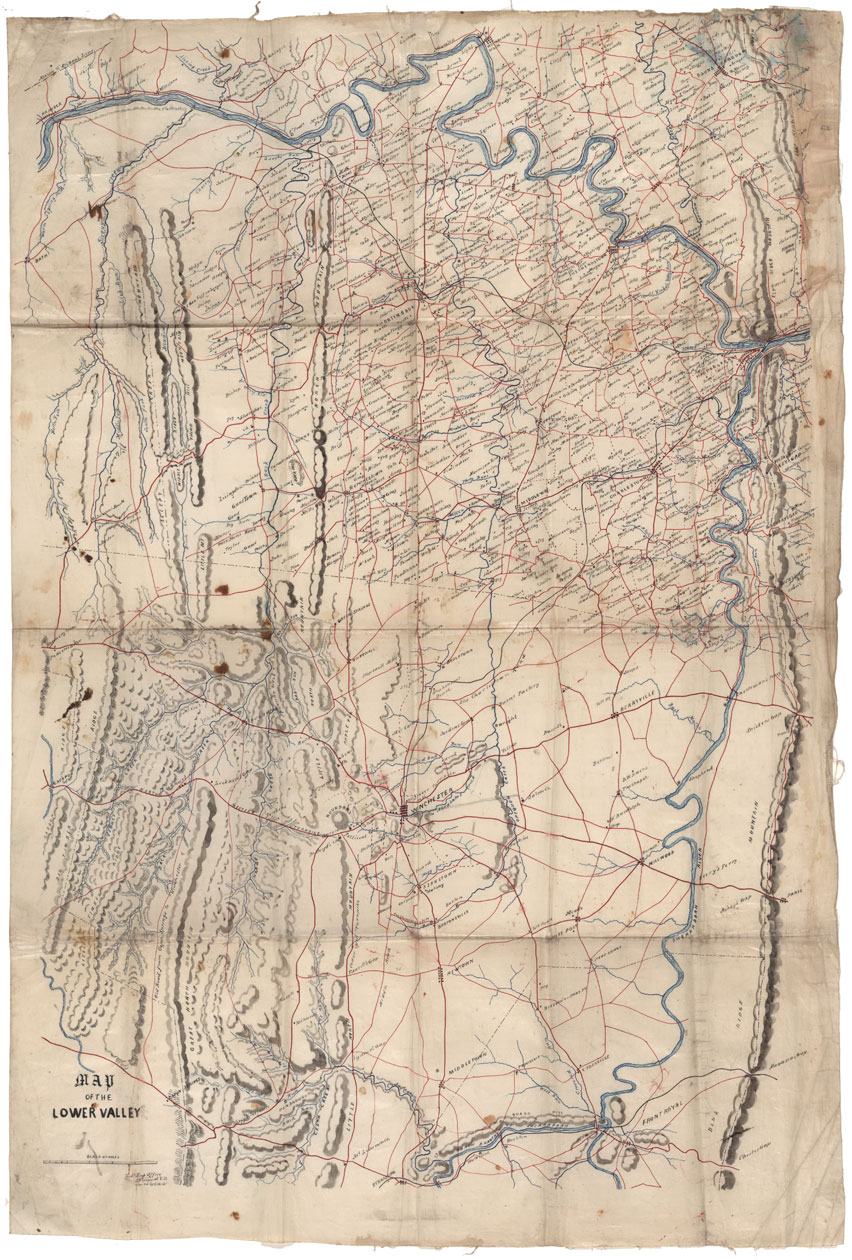
In 1863, C.W. Oltmanns, a Confederate topographical engineer, copied the Map of the Lower Valley (below) from the original drawn by Samuel Howell Brown. Both men worked for Jedidiah Hotchkiss, the chief of General Stonewall Jackson’s topographical staff. It identifies the names of residents living in Jefferson and Berkeley Counties, [West] Virginia, and in Frederick and Clarke Counties, Virginia. Numerous place names are recorded and it is an excellent example of a manuscript Civil War map produced for use in the field.

The annual Voorhees Lecture is presented by the Fry-Jefferson Map Society whose mission is to develop, enhance, and promote the cartographic collections of the Library of Virginia. Alan M. Voorhees was a distinguished engineer and transportation consultant who planned most of the metropolitan and local transportation systems built in the free world in the 1960s and 1970s. A collector of maps since the 1970s, Voorhees made his collection available for research by placing maps, charts, and atlases at the Library of Virginia, the Virginia Historical Society, the Library of Congress, and other institutions. In 1998 and 2003 Voorhees donated to the Library of Virginia maps that focus on the exploration of the Chesapeake Bay area and the development of Virginia within the context of both European and American history. It was a major contribution to the Library’s core collection of more than 12,000 historical maps.
For more information on the Voorhees Lecture please call 804-692-3900 or visit www.lva.virginia.gov/maps. Click here to join the Fry-Jefferson Map Society.
-Cassandra Farrell, Map Specialist & Senior Reference Archivist


