

The 2016 Alan M. and Nathalie Voorhees Lecture on the History of Cartography will be held at the Library of Virginia on Saturday, 16 April 2016. This year’s lecture, Virginia’s District of Columbia, features two guest speakers: Don Hawkins and Dennis Gurtz. Hawkins will present “An Unappreciated Gift,” illustrating the story of Alexandria’s inclusion in 1791 and departure in 1846 from the District of Columbia with contemporary maps and his own cartographic reconstruction of the time period 1791-1846. Gurtz will discuss several maps of the District in his presentation “The Evolving District of Columbia.” The lectures begin at 1:00 PM. An exhibition of maps related to Washington, D.C. from the collections of Gurtz and the Library of Virginia will be on display from 11:00 AM to 4:00 PM. Today’s Out of the Box post presents a sneak preview of two maps from the Library’s collection that will be on display.

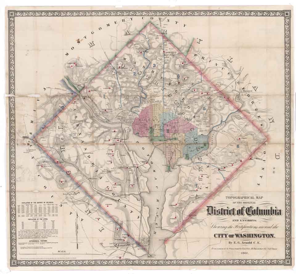
In 1862 civil engineer E.G. Arnold published a topographical map of the District of Columbia that identified the city’s defenses, including the location of fifty-three forts, four batteries and forty army hospitals. Two days after the Colton firm issued Arnold’s map for sale, War Department officials began confiscating any copies they could find, including those already purchased. Federal officials entered private residences to seize copies in their efforts to eradicate any vestige of the map, even traveling to New York City to destroy the lithograph stones. The G. Woolworth Colton publishing firm was compensated when the United States government reimbursed their losses for $8,000. Very few copies of Arnold’s map are extant today.
“Plan of the Town of Alexandria, D.C.” was issued by Thomas Sinclair in 1845, shortly before the town was retro-ceded to Virginia. Surveyor Maskell C. Ewing had drawn surveys of planned extensions to Hunting Creek and the Alexandria Canal. The map shows the topographical detail of streets, turnpikes, canals, and a race course, property owners, and many place names. A handwritten note above the remarks section indicates that the lots circled in ink were the subject of a title dispute between the children of Charles Alexander, Sr. and Charles Alexander, Jr.

The annual Voorhees Lecture is presented by the Fry-Jefferson Map Society, whose mission is to develop, enhance, and promote the cartographic collections of the Library of Virginia. Alan M. Voorhees was a distinguished engineer and transportation consultant who planned most of the metropolitan and local transportation systems built in the free world in the 1960s and 1970s. A collector of maps since the 1970s, Voorhees made his collection available for research by placing maps, charts, and atlases at the Library of Virginia, the Virginia Historical Society, the Library of Congress, and other institutions. In 1998 and 2003 Voorhees donated maps to the Library of Virginia that focus on the exploration of the Chesapeake Bay area and the development of Virginia within the context of both European and American history. It was a major contribution to the Library’s core collection of more than 12,000 historical maps. For more information on the Voorhees Lecture please call 804-692-3900 or visit www.lva.virginia.gov/maps. Click here to join the Fry-Jefferson Map Society.
-Cassandra B. Farrell, Senior Map Archivist, Collections Access and Management Services


