

The earliest people to hike the Appalachian Trail in Virginia did not have the same experience as those walking it today. In fact, for those who walked the Virginia portion in the 1930s, ‘40s, and early ‘50s, it was not even in the same location. It is a common misconception, dispelled in next month’s book club pick, Philip D’Anieri’s The Appalachian Trail: A Biography, that the trail is composed largely of old pioneer routes when it was largely deliberately planned and cleared.
While a portion of the originally laid trail in Virginia was moved in 1941 to include the picturesque McAfee Knob, in 1952 the entire Virginia portion was moved about 50 miles west to its present location (see map insert).1 A combination of factors went into this decision, including the disruption of the newly created Blue Ridge Parkway to the original trail and the possibility of moving the trail off of private property and onto federal land in the Jefferson National Forest.2

Brandan Buck, “Virginia's Lost Appalachian Trail,” Appalachian Trail Histories, accessed May 13, 2022, https://appalachiantrailhistory.org/items/show/1110.
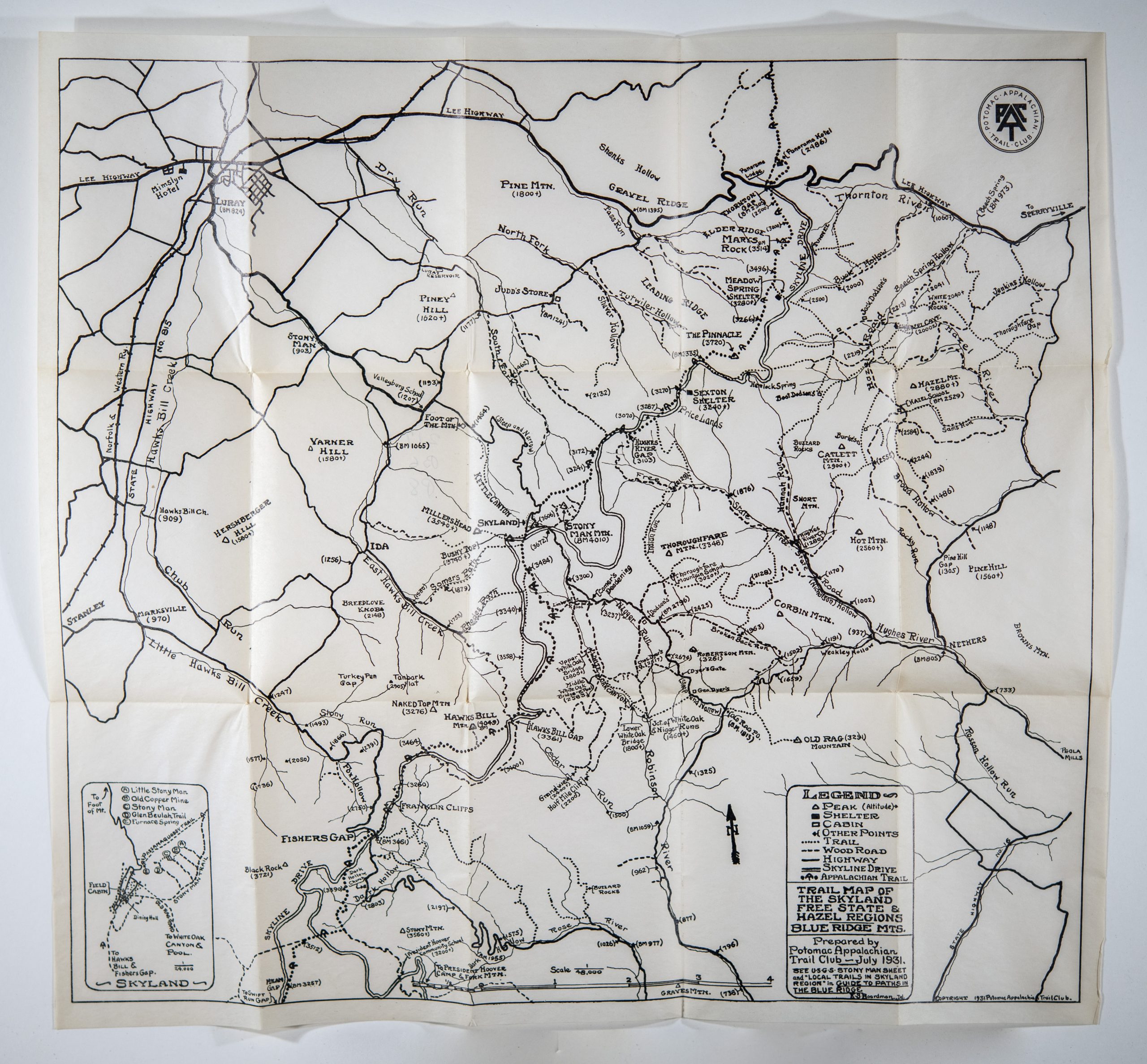
But a hiker in 1931 had a different experience of hiking regardless of the route. While the Potomac Appalachian Trail Club’s Guide to Paths in the Blue Ridge is no longer valuable on the trail itself, it is still an informative and beautiful piece of material culture. The year 1931, of course, was before Google Maps, GIS, and satellites, so these paper maps were (and still are to a lesser extent) essential for navigating the trails. In the early years of the Appalachian Trail, however, even the paper versions of the maps were not as easy to come by. The only official maps were obtained via the Appalachian Trail Conference or the local trail clubs that maintained the different portions of the trail. At this time in Virginia, it was solely the domain of the Potomac Appalachian Trail Club (there are now eight groups). The guide was priced at $2.50 or about $47.55 today.
Once acquired, the 1931 Guidebook was the hiker’s constant companion and had to hold up to its time on the trail. The 1931 edition has a snap enclosure that keeps the pages protected as well as an interior pocket that protects the larger fold-out map of the entire Virginia portion of the trail. The guidebooks and maps changed in many ways with technology advances over the years, but this earliest example in our collection seems more usable than the 1937 pocket version with its microscopic print or the 1941 version with its fold-out maps that never seem to quite fold back in flat. But, it is still just paper, not the coated waterproof trail maps common today, and susceptible to the elements and wear and tear of the trail.


Mapping technology has come a long way as well. The guidebook contains one large fold-out map and then maps of smaller sections of the trail, all of which are hand-drawn and very general in nature. In order to supplement this, a large portion of the guidebook actually consists of descriptive directions on how to remain on the trail, noting private businesses and residences that bisect the trail and might be able to afford lodging and food. A typical section reads:
Pass road to the Rapidan River on right at 14 m. and go through gate in wire fence immediately afterward (14.04 m.). Road descends open slope and becomes obscure in places in open fields. In sag at small ledge (elevation 3,257 ft.) take fainter right fork. (Better-worn left fork leads off to Tanner’s Ridge.) From ledge continue up open slope. At top (15.43 m.) cross bars into dirt road to left and within 10 yds. go through gate in wire fence. Road swings right and descends open slope, passing through gate at 15.89 m. About 10 yds. beyond gate take left fork through clump of chestnut trees and at 15.96 m. enter road from the Marine camp opposite farm of June Weakley. (To the Marine camp it is 2.75 miles, to the President’s camp 3.71 miles, from this turn.). Turn left opposite entrance to cabin and pass through alder-grown section where brook overflows the Trail, then pass through gate. Road climbs hill, passing the Frank Weakley place on left at 16.02 m., and goes through gate at top of hill at 16.22 m.3
At one point the guide also instructs hikers to cross a baseball diamond “diagonally from first to third base and beyond foul-line cross bars and enter woods.”4
While the 2019 edition of the Central Virginia AT trail guidebook points out its “omnidirectional format [that] allows you to see where you are whether southbound or northbound,” in order to be usable in both directions, the descriptive directions in the 1931 version are repeated twice: once for North to South, and again South to North.5 The 1931 guide also includes some information regarding how to treat medical emergencies on the trail, how to identify local plants, and an area for notes.

Drawing showing suggested emergency aid for wounded hikers.
Guide to Paths in the Blue Ridge; Measured Distances and Detailed Directions for 506 Miles of the Appalachian Trail and 65 Miles of Side Trails in Virginia and Adjacent States (1931)
The 1935 Trail Manual issued by the Appalachian Trail Conference (ATC) to help standardize the markings of the trail declares the “sole purpose” of the trail to be “pleasure and recreation.” A hike is always more enjoyable when one does not get lost, which makes both these guidebooks and the signage on the trail extremely important. The manual estimated the life of a trail sign to be between five to seven years, but signs for the old Virginia route – “The lost Appalachian Trail” – could still be seen as late the 1980s, more than thirty years after the route had been abandoned by the official ATC.6 Perhaps they are there still, just like the guidebooks on our shelves, standing testament to history.
–Jessi Bennett, Digital Collections Specialist, and Rebecca Schneider, Senior Reference Librarian
Common Ground Virginia History Book Group
Join us virtually on June 21st, at 6pm to chat with author Philip D’Anieri about his book, The Appalachian Trail: A Biography
Resources
Books
Anderson, Larry. Benton MacKaye: Conservationist, Planner, and Creator of the Appalachian Trail. Baltimore: Johns Hopkins University Press, 2002.
Bratton, Susan. The Spirit of the Appalachian Trail: Community, Environment, and Belief on a Long-Distance Hiking Path. Knoxville: The University of Tennessee Press, 2012.
Brill, David. As Far as the Eye Can See: Reflections of an Appalachian Trail Hiker. Knoxville: University of Tennessee Press, 2013.
Bryson, Bill. A Walk in the Woods: Rediscovering America on the Appalachian Trail. New York: Broadway Books, 1999.
Emblidge, David. The Appalachian Trail Reader. New York: Oxford University Press, 1996.
Luxenberg, Larry. Walking the Appalachian Trail. Mechanicsburg, PA: Stackpole Books, 1994.
Mass, Leslie. In Beauty May She Walk: Hiking the Appalachian Trail at 60. Jacksonville, Fla: Rock Spring Press, 2005.
Marshall, Ian. Story Line: Exploring the Literature of the Appalachian Trail. Charlottesville: University Press of Virginia, 1998.
Mittlefehldt, Sarah, and William Cronon. Tangled Roots: The Appalachian Trail and American Environmental Politics. Seattle: University of Washington Press, 2013.
Niedzaliek, Carol. A Footpath in the Wilderness: The Early Days of PATC. Vienna, VA: Potomac Appalachian Trail Club, 2003.
Shaffer, Earl V. Walking with Spring: The First Thru-Hike of the Appalachian Trail. Harpers Ferry, WV: Appalachian Trail Conference, 1983.
Sherman, Steve, and Julia Older. Appalachian Odyssey: Walking the Trail from Georgia to Maine. Brattleboro, VT: S. Greene Press, 1977.
Sutton, Ann, and Myron Sutton. The Appalachian Trail: Wilderness on the Doorstep. Philadelphia: Lippincott, 1967.
Websites: Trail History
Appalachian Trail Conservancy History
Earl Shaffer’s Appalachian Trail Diary (Smithsonian Institution)
The Green Tunnel Podcast (George Mason University)
Potomac Appalachian Trail Club History
USGS TopoView (United States Geological Survey)
Virginia’s Lost AT (George Mason University)
Websites: Hiking the Trail
Appalachian Long Distance Hikers Association
Appalachian National Scenic Trail (National Park Service)
Appalachian Trail Clubs (National Park Service)
Blue Ridge Parkway (National Park Service)
Potomac Appalachian Trail Club
Shenandoah National Park (National Park Service)
Footnotes
- Kelly, Mills. “The Trail Moves Away.” Appalachian Trail Histories. Department of History and Art History at George Mason University. Accessed May 13, 2022. https://appalachiantrailhistory.org/exhibits/show/lostapptrail/lostatmoves.
- Ibid
- Guide to Paths in the Blue Ridge; Measured Distances and Detailed Directions for 506 Miles of the Appalachian Trail and 65 Miles of Side Trails in Virginia and Adjacent States. Washington, D. C: Potomac Appalachian Trail Club, Incorporated, 1931.
- Ibid
- “Appalachian Trail Guide to Central Virginia Book and Maps Set: Includes: At Guide Central Virginia and at Official Map Central Virginia Maps 1-4.” The Mountaineers. Accessed May 13, 2022. https://www.mountaineers.org/books/books/appalachian-trail-central-virginia-guide-book-map-set.
- The Mountain Laurel, June 01, 1984, https://virginiachronicle.com/?a=d&d=ML19840601.1.2&srpos=1&e=——-en-20–1–txt-txIN-%22Appalachian+trail%22——-.


