

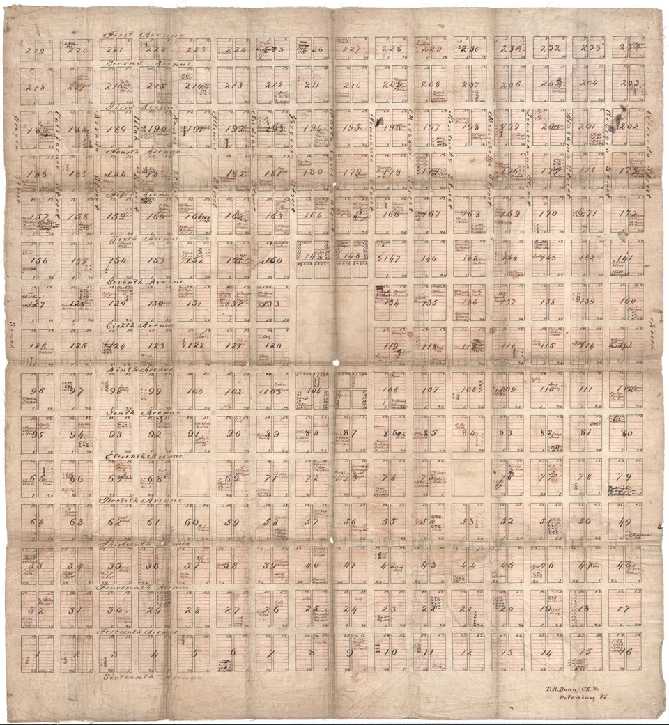
The Library of Virginia began accessioning maps in 1911. Today its collection has grown to encompass several types of maps, including town plans. One of those plans is currently the center of a mystery for Library of Virginia staff members. Completed by Thomas R. Dunn in the late 19th century, it is drawn with pen and ink on cloth and measures 29 1/2 x 27 1/8 inches. The featured town is 16 blocks wide and 15 blocks high with 4 block spaces in the center. Streets running horizontally are named after states: Oregon, California, Nevada, Utah, Kansas, Illinois, Indiana, Virginia, North Carolina, Tennessee, Missouri, Kentucky, Mississippi, Louisiana, Alabama, Georgia and Colorado. Vertically-laid streets are identified sequentially from First Avenue to Sixteenth Avenue. Beyond this basic information, the plan is unnamed and unidentified. What town does it represent?

Unidentified town plan by Thomas R. Dunn.
Library of Virginia Maps Collection.
Dunn did notate the plan but he didn’t include an index to explain the numerous abbreviations. Several lots are identified by surnames but we haven’t been able to verify if they represent the names of lot owners. A search through ProQuest’s digital Sanborn maps collection was not conclusive but there are several Virginia localities that include sections similar to Dunn’s plan, including Portsmouth. The 1920 Sanborn map of the City of Portsmouth is the first we know of featuring a similarly-laid section.
So, what more do we know? T.R. Dunn’s plan resembles other town plans drafted and built in the second half of the 19th century. Dunn was a civil engineer and surveyor who lived in Petersburg and worked in central and southside Virginia. By 1900 he was the city engineer and superintendent of water works for the City of Petersburg.
Dunn’s work is represented in several chancery records that are a part of the Library’s online Chancery Records Index collection. Researchers can access plats drawn by Dunn and used as evidence in several court cases heard in the City of Petersburg, and in Prince George and Dinwiddie Counties, such as:
- Petersburg City, 1884-014, J.W. Gates & Wife v. Robert Crostich
- Petersburg City, 1895-088, City of Petersburg v. B.S. Burch, etc.
- Prince George County, 1891-002, R.S. Lockett, etc. v. Lula M. Lockett Widow, etc.
- Dinwiddie County, 1891-008, Griff Green v. W. M. Stern, etc.
We are seeking the public’s help in identifying this town plan. If you are able to provide any information that will help us, or if you are interested in viewing the plan (Map Accession 5870), please contact Map Specialist Cassandra Farrell at cassandra.farrell@lva.virginia.gov.
-Cassandra Farrell, Map Specialist & Senior Reference Archivist


