

Yorktown Day marks the anniversary of the 19 October 1781 surrender of British forces to General George Washington ending the Revolutionary War. To celebrate, the Library is highlighting two maps in our collection related to the decisive battle at Yorktown.
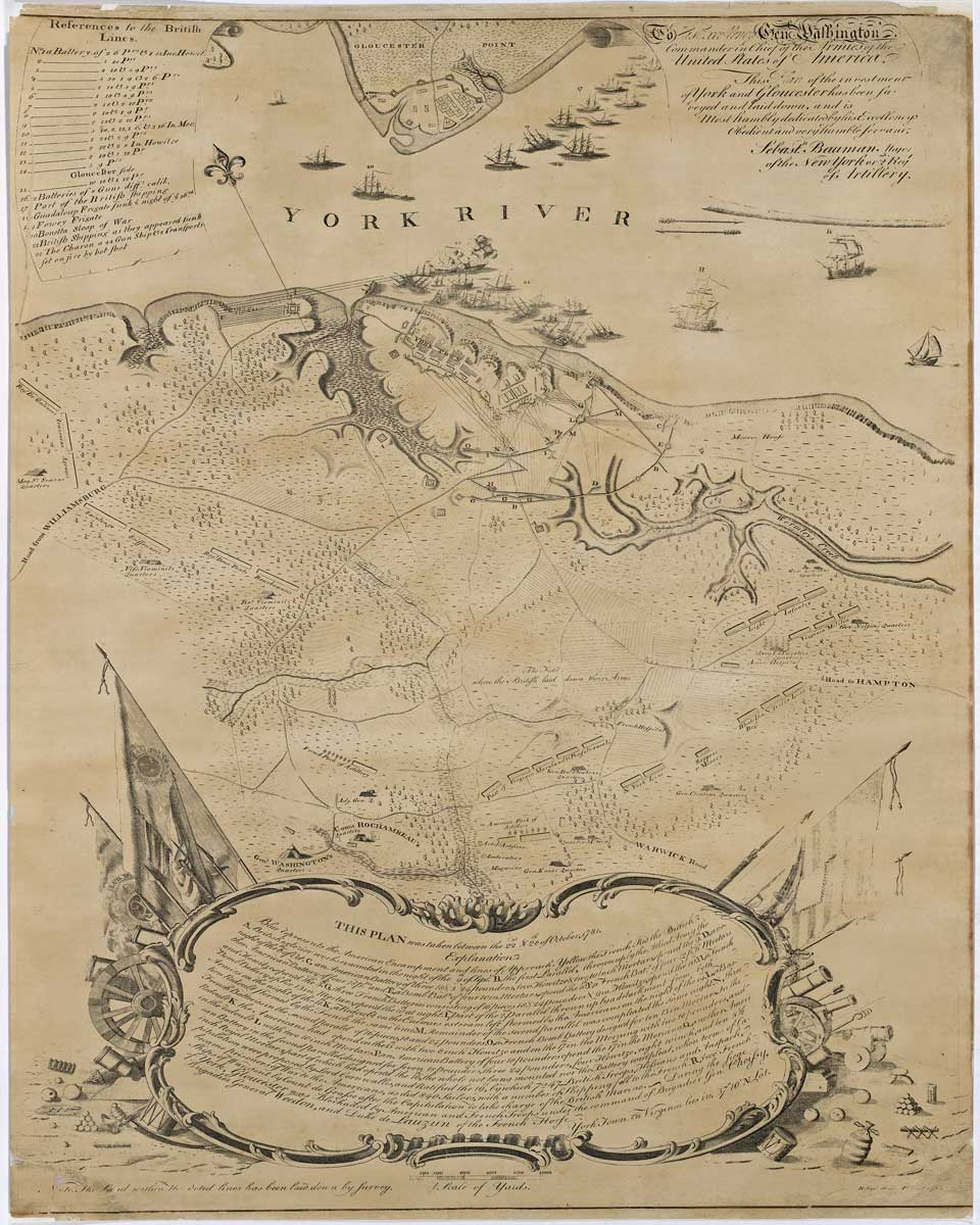
In 1956 the Library of Virginia purchased Sebastian Bauman’s A Plan of the Investment of York and Gloucester (1782) from Henry Stevens of Son & Stiles. At the Battle of Yorktown in 1781, Bauman commanded one of the allied batteries; he began drafting his map of the Yorktown battlefield shortly after British General Charles Cornwallis surrendered to General George Washington. His map was the first published in America to depict the American and French victory at the sleepy Virginia port town situated along the York River.
Engraved by Robert Scot of Philadelphia, the map was sold by subscription. Many viewers are immediately drawn to the elaborate scrollwork design along the map’s lower center, made up of flags, cannons, cannonballs, swords, drums, and trumpets.

Within it is a description of the letters of the alphabet that identify specific locations on the battlefield. References to the British lines are printed in the upper left corner and the dedication and title are printed on rolled parchment on the map’s upper right corner.
Sebastian Bauman was trained in surveying and mapping as a soldier in the Austrian Army. He immigrated to the American colonies before the outbreak of the French and Indian War. In 1777 he was assigned to the 2nd Continental Regiment of Artillery, was promoted to major and served as artillery commander at West Point in 1779. He was sent to Yorktown in 1781.

In 1824-1826 former Revolutionary War general, the Marquis de Lafayette, visited the United States at the request of President James Monroe. He toured the United States and was warmly received by the American public. In commemoration of Lafayette’s visit the Plan of York Town in Virginia and Adjacent Country, drawn by John Francis Renault and engraved by Harry S. Tanner, was published in Philadelphia. It is based on Bauman’s map of Yorktown. The border is decorated with flowers and an ornate design of flags, cannons, cannonballs, drums and weapons make up the map’s lower center. An explanation of letters of the alphabet is above this ornate design and below Renault’s battlefield drawing. The title is printed in a simply decorated cartouche on the map’s upper left side and references to the British lines are listed on the upper right hand side. leo.
Mr. Joseph G. Fiveash gifted Plan of York Town in Virginia and Adjacent Country to the Library of Virginia in April 1905.
-Cassandra B. Farrell, Senior Map Archivist, Collections Access and Management Services
Bibliography
Brown, Richard H and Paul E. Cohen. Revolution: Mapping the Road to American Independence, 1755-1783. New York: W.W. Norton and Company, 2015.
Pritchard, Margaret Beck and Henry G. Taliaferro. Degrees of Latitude: Mapping Colonial America. Williamsburg, Virginia: Colonial Williamsburg Foundation, in association with Harry N. Abrams, 2002.
Gerson, Noel B. Statute in Search of a Pedestal: A Biography of the Marquis de Lafayette. New York: Dodd, Mead & Company, 1976.


